
Mapa topográfico Irun
Mapa interactivo
Haga clic en el mapa para ver la altitud.
Acerca de este mapa
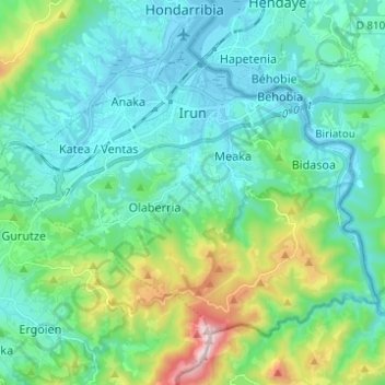
Nombre: Mapa topográfico Irun, altitud, relieve.
Altitud media: 163 m
Altitud mínima: -4 m
Altitud máxima: 794 m
Otros mapas topográficos
Haga clic en un mapa para ver su topografía, su altitud y su relieve.
Hondarribia/Fontarrabie
Spain > Autonomous Community of the Basque Country > Bidasoa Beherea / Bajo Bidasoa
Hondarribia/Fontarrabie, Bidasoa Beherea / Bajo Bidasoa, Gipuzkoa, Autonomous Community of the Basque Country, 20280, Spain
Altitud media: 37 m
Hondarribia
Spain > Autonomous Community of the Basque Country > Bidasoa Beherea / Bajo Bidasoa > Hondarribia
Hondarribia, Bidasoa Beherea / Bajo Bidasoa, Gipuzkoa, Autonomous Community of the Basque Country, Spain
Altitud media: 34 m