
Mapa topográfico Portocheli
Mapa interactivo
Haga clic en el mapa para ver la altitud.
Acerca de este mapa
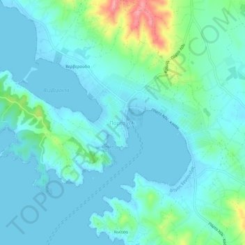
Nombre: Mapa topográfico Portocheli, altitud, relieve.
Altitud media: 19 m
Altitud mínima: -2 m
Altitud máxima: 105 m
Otros mapas topográficos
Haga clic en un mapa para ver su topografía, su altitud y su relieve.
Δορούφι Κοιλάδος
Greece > Peloponnese, Western Greece and the Ionian > Argolis Regional Unit > Municipal Unit of Kranidi
Δορούφι Κοιλάδος, Κοινότητα Κοιλάδος, Municipal Unit of Kranidi, Municipality of Ermionida, Argolis Regional Unit, Peloponnese Region, Peloponnese, Western Greece and the Ionian, 213 00, Greece
Altitud media: 30 m
Petrothalassa
Greece > Peloponnese, Western Greece and the Ionian > Argolis Regional Unit > Municipal Unit of Kranidi
Petrothalassa, Municipal Unit of Kranidi, Municipality of Ermionida, Argolis Regional Unit, Peloponnese Region, Peloponnese, Western Greece and the Ionian, 213 00, Greece
Altitud media: 24 m
Kranidi
Greece > Peloponnese, Western Greece and the Ionian > Argolis Regional Unit > Municipal Unit of Kranidi
Kranidi, Municipal Unit of Kranidi, Municipality of Ermionida, Argolis Regional Unit, Peloponnese Region, Peloponnese, Western Greece and the Ionian, 213 00, Greece
Altitud media: 77 m