
Mapa topográfico Amorgos
Mapa interactivo
Haga clic en el mapa para ver la altitud.
Acerca de este mapa
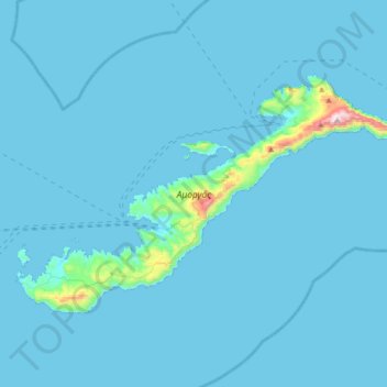
Nombre: Mapa topográfico Amorgos, altitud, relieve.
Altitud media: 28 m
Altitud mínima: 0 m
Altitud máxima: 819 m
Otros mapas topográficos
Haga clic en un mapa para ver su topografía, su altitud y su relieve.
Naxos
Greece > Aegean > Naxos Regional Unit
Naxos, Naxos Regional Unit, South Aegean, Aegean, Greece
Altitud media: 112 m
Naxos
Greece > Aegean > Naxos Regional Unit
Naxos, Municipality of Naxos and the Lesser Cyclades, Naxos Regional Unit, South Aegean, Aegean, 843 00, Greece
Altitud media: 33 m
Keros
Greece > Aegean > Naxos Regional Unit
Keros, Municipality of Naxos and the Lesser Cyclades, Naxos Regional Unit, South Aegean, Aegean, Greece
Altitud media: 42 m