
Haz una donación
Mapa topográfico Wasagaming
Haga clic en el mapa para ver la altitud.
Haz una donación
Wasagaming
Wasagaming has a subarctic climate (Dfc) due to its northerly location and high elevation. Winters are extremely cold and relatively dry with little chance of a mid-winter thaw. The average annual temperature is 0.7 °C (33.3 °F). Annual precipitation is 488 mm (19.2 in).
Haz una donación
Acerca de este mapa
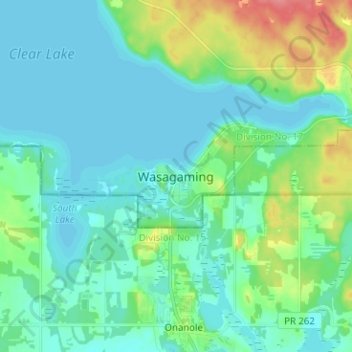
Nombre: Mapa topográfico Wasagaming, altitud, relieve.
Altitud media: 630 m
Altitud mínima: 615 m
Altitud máxima: 683 m
Haz una donación
Otros mapas topográficos
Haga clic en un mapa para ver su topografía, su altitud y su relieve.
Riding Mountain National Park
Canada > Manitoba > Unorganized Division No. 17 > Wasagaming
Riding Mountain Biosphere Reserve covers 15,000 square kilometers of land in South-western Manitoba, with the core area, Riding Mountain National Park (RMNP), covering nearly 3,000 square kilometers. It is some 300 km northwest of Winnipeg, Manitoba. The local climate is cool and moist due to a higher…
Altitud media: 488 m