
Haz una donación
Mapa topográfico Lakemont
Haga clic en el mapa para ver la altitud.
Haz una donación
Acerca de este mapa
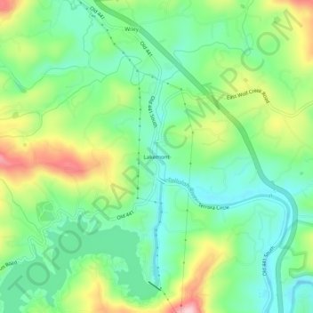
Nombre: Mapa topográfico Lakemont, altitud, relieve.
Lugar: Lakemont, Rabun County, Georgia, 30581, United States (34.76204 -83.43628 34.80204 -83.39628)
Altitud media: 547 m
Altitud mínima: 474 m
Altitud máxima: 684 m
Haz una donación
Otros mapas topográficos
Haga clic en un mapa para ver su topografía, su altitud y su relieve.
Sky Valley
United States > Georgia > Rabun County
According to the United States Census Bureau, the city has a total area of 3.0 square miles (7.8 km2), all land. The elevation of the valley floor is approximately 3100 feet above sea level, while areas within the city limits on the slopes of Rabun Bald exceed 4200 feet. Sky Valley is Georgia's highest…
Altitud media: 973 m
Mountain City
United States > Georgia > Rabun County
Mountain City is an incorporated town in Rabun County, Georgia, United States. The population was 904 at the 2020 census. The town straddles the Eastern Continental Divide in a deep gap in the Blue Ridge Mountain front. The gap allows U.S. Route 441 to cross the range at an elevation of 2168 feet without the…
Altitud media: 747 m
Haz una donación
Tiger
United States > Georgia > Rabun County
Tiger lies in the extreme northeastern part of the state, just a few miles west of the Georgia-South Carolina border, and a few miles south of the Georgia-North Carolina border. The town's elevation is 1,962 feet (598 m), with several wooded hilltops reaching elevations of 2,100 to 2,200 feet. The town sits at…
Altitud media: 608 m
Haz una donación
Sky Valley
United States > Georgia > Rabun County
According to the United States Census Bureau, the city has a total area of 3.0 square miles (7.8 km2), all land. The elevation of the valley floor is approximately 3100 feet above sea level, while areas within the city limits on the slopes of Rabun Bald exceed 4200 feet. Sky Valley is Georgia's highest…
Altitud media: 973 m
Tiger
United States > Georgia > Rabun County
Tiger lies in the extreme northeastern part of the state, just a few miles west of the Georgia-South Carolina border, and a few miles south of the Georgia-North Carolina border. The town's elevation is 1,962 feet (598 m), with several wooded hilltops reaching elevations of 2,100 to 2,200 feet. The town sits at…
Altitud media: 608 m