
Haz una donación
Mapa topográfico Sunshine Coast Regional District
Haga clic en el mapa para ver la altitud.
Haz una donación
Acerca de este mapa
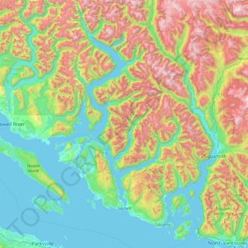
Nombre: Mapa topográfico Sunshine Coast Regional District, altitud, relieve.
Lugar: Sunshine Coast Regional District, British Columbia, Canada (49.29734 -124.28426 50.36670 -123.24689)
Altitud media: 699 m
Altitud mínima: 0 m
Altitud máxima: 2.623 m
Haz una donación
Otros mapas topográficos
Haga clic en un mapa para ver su topografía, su altitud y su relieve.
Shawnigan Lake
Canada > British Columbia > Cowichan Valley Regional District > Area B (Shawnigan Lake)
Altitud media: 128 m
Haz una donación
Purcell Mountains
Canada > British Columbia > Regional District of East Kootenay > Area G (Forster Creek/Mount Assiniboine)
Altitud media: 2.710 m
Rock Creek
Canada > British Columbia > Regional District of Kootenay Boundary > Area E (Beaverdell/West Boundary)
Altitud media: 764 m
Blind Bay
Canada > British Columbia > Columbia-Shuswap Regional District > Area C (Blind Bay/Sorrento)
Altitud media: 414 m
Stanley Park
Canada > British Columbia > Metro Vancouver Regional District > Vancouver
Altitud media: 14 m
Haz una donación
Triple Peak
Canada > British Columbia > Alberni-Clayoquot Regional District > Area C (Long Beach)
Altitud media: 938 m
Lund
Canada > British Columbia > qathet Regional District > Area A (Malaspina/Toba)
Altitud media: 57 m
Haz una donación
Burnaby
Canada > British Columbia > Metro Vancouver Regional District > Burnaby
Burnaby occupies 98.60 square kilometres (38.07 sq mi) and is located at the geographic centre of the Metro Vancouver area and home to the Metro Vancouver regional government in Metrotown. Situated between the city of Vancouver on the west and Port Moody, Coquitlam, and New Westminster on the east, Burnaby is…
Altitud media: 144 m
Cawston
Canada > British Columbia > Regional District of Okanagan-Similkameen > Area B (Cawston/Lower Similkameen)
Altitud media: 410 m
Lac Le Jeune
Canada > British Columbia > Thompson-Nicola Regional District > Area J (Copper Desert Country)
Altitud media: 1.309 m
Haz una donación
Grouse Mountain
Canada > British Columbia > Metro Vancouver Regional District
Grouse Mountain is one of the North Shore Mountains of the Pacific Ranges in the District Municipality of North Vancouver, British Columbia, Canada. With a maximum elevation of over 1,200 m (4,100 feet) at its peak, the mountain is the site of an alpine ski area, Grouse Mountain Resort, which overlooks Greater…
Altitud media: 968 m
Silver Star Mountain Resort
Canada > British Columbia > Regional District of North Okanagan > Area C (Silver Star)
Altitud media: 1.584 m
Haz una donación
Mill Bay
Canada > British Columbia > Cowichan Valley Regional District > Area A (Mill Bay / Malahat)
Altitud media: 61 m
Annacis Island
Canada > British Columbia > Metro Vancouver Regional District > Delta
Altitud media: 16 m
Cobble Hill
Canada > British Columbia > Cowichan Valley Regional District > Area C (Cobble Hill)
Altitud media: 116 m
Haz una donación
Coast Mountains
Canada > British Columbia > Area A (Seymour Inlet/Knight Inlet)
The Coast Mountains are part of the Pacific Ring of Fire—the ring of volcanoes and associated mountains around the Pacific Ocean—and contain some of British Columbia's highest mountains. Mount Waddington is the highest mountain of the Coast Mountains and the highest that lies entirely within British…
Altitud media: 1.951 m
Haz una donación
Kootenay National Park
Canada > British Columbia > Regional District of East Kootenay
Kootenay National Park is a national park located in southeastern British Columbia, Canada, and is one component of the Canadian Rocky Mountain Parks World Heritage Site. The park consists of 1,406 km2 (543 sq mi) of the Canadian Rockies, including parts of the Kootenay and Park mountain ranges, the Kootenay…
Altitud media: 1.832 m
Haz una donación
White Rock
Canada > British Columbia > Metro Vancouver Regional District > White Rock > White Rock
Altitud media: 38 m
Kamloops
Canada > British Columbia > Thompson-Nicola Regional District > Kamloops
Altitud media: 875 m
Haz una donación
Prince George
Canada > British Columbia > Regional District of Fraser-Fort George > Prince George
Altitud media: 708 m
Haz una donación
Dease Lake
Canada > British Columbia > Regional District of Kitimat-Stikine > Area F (Dease Lake)
Dease Lake has a subarctic climate (Köppen Dfc), typical of northern British Columbia. Summers are mild, coupled with chilly nights while winters are severely cold and snowy, with annual snowfall averaging 212.8 cm (83.78 in). Autumn typically begins by early September and lasts into October when winter…
Altitud media: 898 m
Haz una donación
Pavilion
The early anglicized version of the village name was Skwailuk, meaning hoar-frost, perhaps indicating the shaded ground remaining frozen during the long winters at this elevation. The Ts'kw'aylaxw First Nation (a.k.a. the Tsk'waylacw First Nation or Tsk'weylecw First Nation), residing on the Pavilion 1 Indian…
Altitud media: 855 m
Haz una donación
Haz una donación
Panorama Mountain
Canada > British Columbia > Regional District of Kitimat-Stikine > Area A (Nass Valley/Bell Irving)
Altitud media: 1.609 m
Haz una donación
Haz una donación
Fishtail Lake
Canada > British Columbia > Regional District of Nanaimo > Area C (Arrowsmith-Benson)
Altitud media: 1.155 m
Alleyne Lake
Canada > British Columbia > Thompson-Nicola Regional District > Area N (Beautiful Nicola Valley - South)
Altitud media: 1.089 m
Fraserview
Canada > British Columbia > Regional District of Fraser-Fort George > Prince George
Altitud media: 590 m
Blakeburn
Canada > British Columbia > Regional District of Okanagan-Similkameen > Area H (Manning Park/Tulameen/Siwash)
Altitud media: 1.188 m
Haz una donación
Whitehorn Mountain
Canada > British Columbia > Regional District of Fraser-Fort George > Area H (Robson Valley/Canoe)
Altitud media: 2.553 m
Silver Star Mountain
Canada > British Columbia > Regional District of North Okanagan > Area C (Silver Star)
Altitud media: 1.706 m
Bankeir
Canada > British Columbia > Regional District of Okanagan-Similkameen > Area H (Manning Park/Tulameen/Siwash)
Altitud media: 1.226 m
Haz una donación
Garnet Valley Dam
Canada > British Columbia > Regional District of Okanagan-Similkameen > Summerland
Altitud media: 799 m
Whistler
Canada > British Columbia > Squamish-Lillooet Regional District > Whistler Resort Municipality > Whistler
Altitud media: 996 m
Langley Township
Canada > British Columbia > Metro Vancouver Regional District > Township of Langley > Langley Township
Altitud media: 37 m
Haz una donación
Falkland
Canada > British Columbia > Columbia-Shuswap Regional District > Area D (Falkland/Silver Creek)
Altitud media: 786 m
Silvertip Mountain
Canada > British Columbia > Columbia-Shuswap Regional District > Area A (Kicking Horse/Kinbasket Lake)
Altitud media: 2.443 m
Whitecroft
Canada > British Columbia > Thompson-Nicola Regional District > Area P (Rivers and the Peaks)
Altitud media: 1.000 m
Earls Cove
Canada > British Columbia > Sunshine Coast Regional District > Area A (Egmont/Pender Harbour)
Altitud media: 84 m
Haz una donación
The Bugaboos
Canada > British Columbia > Regional District of East Kootenay > Area G (Forster Creek/Mount Assiniboine)
Altitud media: 2.412 m
Pinantan Lake
Canada > British Columbia > Thompson-Nicola Regional District > Area P (Rivers and the Peaks)
Altitud media: 971 m
Edith Lake
Canada > British Columbia > Squamish-Lillooet Regional District > Squamish
Altitud media: 309 m
Crawford Bay
Canada > British Columbia > Regional District of Central Kootenay > Area A (Wynndel/Crawford Bay/Riondel)
Altitud media: 667 m
Haz una donación
Harrison Mills
Canada > British Columbia > Fraser Valley Regional District > Area C (Sasquatch Country)
Altitud media: 95 m
Vallican
Canada > British Columbia > Regional District of Central Kootenay > Area H (The Slocan Valley)
Altitud media: 821 m
Pogo Mountain
Canada > British Columbia > Alberni-Clayoquot Regional District > Area C (Long Beach)
Altitud media: 818 m
Hemlock Valley
Canada > British Columbia > Fraser Valley Regional District > Area C (Sasquatch Country)
Altitud media: 1.106 m
Haz una donación
Mount Sproatt
Canada > British Columbia > Squamish-Lillooet Regional District > Whistler
Altitud media: 1.533 m
Haz una donación
Royston
Canada > British Columbia > Comox Valley Regional District > Area A (Baynes Sound)
Altitud media: 29 m
Sunshine Valley
Canada > British Columbia > Fraser Valley Regional District > Area B (South Fraser Canyon/Sunshine Valley)
Altitud media: 1.030 m
Coquitlam
Canada > British Columbia > Metro Vancouver Regional District > Coquitlam
Southwest Coquitlam comprises the original core of the city, with Maillardville and Fraser River industrial sector giving way to the large residential areas of Austin Heights, colloquially referred to as "The Bump" due to its high and flat plateau topography. These older residences, with larger property…
Altitud media: 230 m
Abbotsford
Canada > British Columbia > Fraser Valley Regional District > Abbotsford
Altitud media: 115 m
Haz una donación
South Hazelton
Canada > British Columbia > Regional District of Kitimat-Stikine > Area B (Suskwa/Kitwanga/Kispiox) > South Hazelton
Altitud media: 278 m
Okanagan Highland
Canada > British Columbia > Regional District of Okanagan-Similkameen > Area E (Naramata/Greyback)
Altitud media: 816 m
Hazelton
Canada > British Columbia > Regional District of Kitimat-Stikine > Hazelton > Hazelton
Altitud media: 266 m
Haz una donación
Hoodoo Mountain
Canada > British Columbia > Regional District of Kitimat-Stikine > Area D (Iskut/Big Raven)
Hoodoo Mountain, sometimes referred to as Hoodoo Volcano, is a potentially active stratovolcano in the Northern Interior of British Columbia, Canada. It is located 25 kilometres (16 miles) northeast of the Alaska–British Columbia border on the north side of the Iskut River opposite of the mouth of the Craig…
Altitud media: 1.657 m
View Royal
Canada > British Columbia > Capital Regional District > View Royal > View Royal
Altitud media: 34 m
Grizzly Peak
Canada > British Columbia > Regional District of East Kootenay > Area A (Upper Flathead/Elk Valley)
Altitud media: 1.962 m
View Lake
Canada > British Columbia > Alberni-Clayoquot Regional District > Area D (Sproat Lake)
Altitud media: 393 m
Haz una donación