
Gracias por apoyar a este sitio ❤️
Haz una donación
Haz una donación
Mapa topográfico Bella Coola
Haga clic en el mapa para ver la altitud.
Gracias por apoyar a este sitio ❤️
Haz una donación
Haz una donación
Bella Coola
There is a 454 km mostly paved road connection by Highway 20 to Williams Lake. The road was built in 1953 by local residents, and features a 15 km ascent from the Valley floor to the Chilcotin plateau, gaining 1600m in elevation to the summit at Heckman Pass, via a number of steep grades & switchbacks. The construction of this road was described in the books "Bella Coola" and "A Road Runs West".
Gracias por apoyar a este sitio ❤️
Haz una donación
Haz una donación
Acerca de este mapa
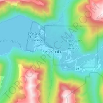
Nombre: Mapa topográfico Bella Coola, altitud, relieve.
Altitud media: 438 m
Altitud mínima: -1 m
Altitud máxima: 1.609 m
Gracias por apoyar a este sitio ❤️
Haz una donación
Haz una donación