
Haz una donación
Mapa topográfico Forest Park
Haga clic en el mapa para ver la altitud.
Haz una donación
Forest Park
Solidified lava from Grande Ronde members of the Columbia River Basalt Group underlie Forest Park. About 16 million years ago during the Middle Miocene, the Columbia River ran through a lowland south of its modern channel. Eruptions from linear vents in eastern Oregon and Washington flowed down this channel through what later became the Willamette Valley. These flows, some of which reached the Pacific Ocean, recurred at intervals between 16.5 and 15.6 million years ago and covered almost 60,000 square miles (160,000 km2). About eight separate Grande Ronde Basalt flows have been mapped in the Tualatin Mountains (West Hills), where they underlie the steepest slopes of Forest Park and form the columned rocks visible along Balch Creek Canyon and Northwest Cornell Road. The West Hills were later covered by wind-deposited silts that become unstable when saturated with water. Stream bank instability and siltation are common, and landslides deter urban development at higher elevations.
Haz una donación
Acerca de este mapa
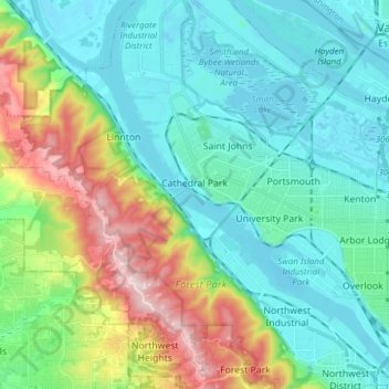
Nombre: Mapa topográfico Forest Park, altitud, relieve.
Altitud media: 91 m
Altitud mínima: -8 m
Altitud máxima: 384 m
Haz una donación
Otros mapas topográficos
Haga clic en un mapa para ver su topografía, su altitud y su relieve.