
Mapa topográfico North Union Township
Mapa interactivo
Haga clic en el mapa para ver la altitud.
North Union Township
The eastern half of Union Township occupies the hilltops and western slope of Chestnut Ridge, with the highest elevation of 2,670 feet (810 m) located near the southeast corner of the township, just north of the Summit Hotel. The lowest point in the township is 910 feet (280 m) above sea level, along Redstone Creek where it exits the township from its northwest corner.
Acerca de este mapa
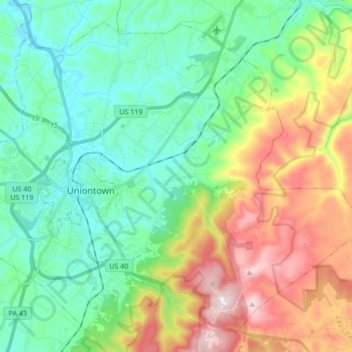
Nombre: Mapa topográfico North Union Township, altitud, relieve.
Altitud media: 447 m
Altitud mínima: 275 m
Altitud máxima: 815 m