
Mapa topográfico Clingmans Dome
Mapa interactivo
Haga clic en el mapa para ver la altitud.
Acerca de este mapa
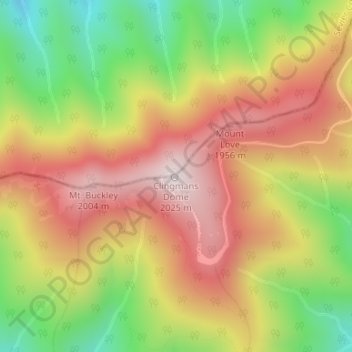
Nombre: Mapa topográfico Clingmans Dome, altitud, relieve.
Lugar: Clingmans Dome, Swain County, North Carolina, United States (35.56281 -83.49843 35.56291 -83.49833)
Altitud media: 1.716 m
Altitud mínima: 1.370 m
Altitud máxima: 2.021 m
Clingmans Dome (or Clingman's Dome) is a mountain in the Great Smoky Mountains of Tennessee and North Carolina in the southeastern United States. Its name in Cherokee is Kuwahi or Kuwohi (ᎫᏩᎯ or ᎫᏬᎯ), meaning "mulberry place." At an elevation of 6,643 feet (2,025 m), it is the highest mountain in the Great Smoky Mountains National Park, the highest point in the state of Tennessee, and the highest point along the 2,192-mile (3,528 km) Appalachian Trail. It is also the third highest point in mainland Eastern North America, after Mount Mitchell (6,684 feet or 2,037 metres) and Mount Craig (6,647 feet or 2,026 metres).
Otros mapas topográficos
Haga clic en un mapa para ver su topografía, su altitud y su relieve.
Cherokee
United States > North Carolina > Swain County > Yellowhill Community
Cherokee, Yellowhill Community, Swain County, North Carolina, 28719, United States
Altitud media: 746 m
Whittier
United States > North Carolina > Swain County
Whittier, Swain County, North Carolina, 28789, United States
Altitud media: 624 m
Cheoah Bald
United States > North Carolina > Swain County
Cheoah Bald, Swain County, North Carolina, United States
Altitud media: 1.274 m
Bryson City
United States > North Carolina > Swain County
Bryson City, Swain County, North Carolina, United States
Altitud media: 592 m