
Mapa topográfico Indianapolis
Mapa interactivo
Haga clic en el mapa para ver la altitud.
Acerca de este mapa
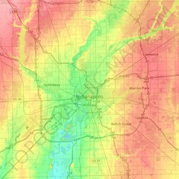
Nombre: Mapa topográfico Indianapolis, altitud, relieve.
Lugar: Indianapolis, Marion County, Indiana, United States (39.63216 -86.32812 39.92753 -85.93804)
Altitud media: 241 m
Altitud mínima: 196 m
Altitud máxima: 283 m
Indianapolis is located within a physiographic province known as the Tipton Till Plain, a flat, gently rolling terrain underlain by glacial deposits known as till. The lowest point in the city is about 650 feet (198 m) above mean sea level, with the highest natural elevation at about 900 feet (274 m) above sea level. Few hills or short ridges, known as kames, rise about 100 feet (30 m) to 130 feet (40 m) above the surrounding terrain. The city lies just north of the Indiana Uplands, a region characterized by rolling hills and high limestone content.
Otros mapas topográficos
Haga clic en un mapa para ver su topografía, su altitud y su relieve.
Drexel Gardens
United States > Indiana > Marion County > Indianapolis
Drexel Gardens, Indianapolis, Marion County, Indiana, 46241, United States
Altitud media: 226 m
Wolfington
United States > Indiana > Marion County > Indianapolis
Wolfington, Indianapolis, Marion County, Indiana, 46228, United States
Altitud media: 230 m
Farleys Addition
United States > Indiana > Marion County > Indianapolis
Farleys Addition, Indianapolis, Marion County, Indiana, 36224, United States
Altitud media: 235 m
Fox Hollow
United States > Indiana > Marion County > Indianapolis > Fox Hollow
Fox Hollow, Indianapolis, Marion County, Indiana, 46239, United States
Altitud media: 252 m
Crows Nest
United States > Indiana > Marion County
Crows Nest, Marion County, Indiana, United States
Altitud media: 229 m