
Mapa topográfico Urbino
Mapa interactivo
Haga clic en el mapa para ver la altitud.
Acerca de este mapa
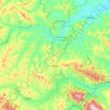
Nombre: Mapa topográfico Urbino, altitud, relieve.
Lugar: Urbino, Pesaro e Urbino, Marche, 61029, Italy (43.66130 12.43501 43.84021 12.77380)
Altitud media: 301 m
Altitud mínima: 30 m
Altitud máxima: 968 m
The century began as had the previous one. This period of quiet lasted for almost the entire first half of the twentieth century, with no particular significant events. In this period, the Scuola del Libro (Istituto per la Decorazione e l'Illustrazione del Libro) was founded and expressed considerable talent both nationally and internationally. In addition to the artistic development from the Scuola del Libro, Urbino also began to grow as a university town, with the elevation to university faculty of nineteenth-century School of Pharmacy and the birth of the department of Education (approximately 1934). Due to these changes in the University, an increase in the student population led to housing shortages that highlighted the state of total unpreparedness of the city, so much that for the first time many students were housed in the homes of private citizens. The problem was partly solved with the establishment of the male boarding school "Raphael" at the beginning of the century, and the female boarding school "Laura Battiferri" in approximately 1926. This period was dominated by great events of national and international history, which inevitably were expressed in Urbino. The period of the fascist dictatorship left its mark on the city, especially from an architectural point of view, with a fascist elementary school "Giovanni Pascoli" (1932) built on the ancient Garden of Saint Lucia (part of the duke's private gardens), the restoration of the palace-Mauruzi Gherardi, then the seat of the court, as well as the Student House, to compensate for the shortage of accommodation as a result of the large increase in university population and housing for the maimed and disabled civilians.
Otros mapas topográficos
Haga clic en un mapa para ver su topografía, su altitud y su relieve.
San Lorenzo in Campo
Italy > Marche > Pesaro e Urbino
San Lorenzo in Campo, Pesaro e Urbino, Marche, 61047, Italy
Altitud media: 203 m
Fossombrone
Italy > Marche > Pesaro e Urbino
Fossombrone, Pesaro e Urbino, Marche, 61034, Italy
Altitud media: 328 m
Sant'Angelo in Vado
Italy > Marche > Pesaro e Urbino
Sant'Angelo in Vado, Pesaro e Urbino, Marche, 61048, Italy
Altitud media: 500 m
Ponte Tavollo
Italy > Marche > Pesaro e Urbino > Pesaro
Ponte Tavollo, Pesaro, Pesaro e Urbino, Marche, 61012, Italy
Altitud media: 43 m
Miralbello
Italy > Marche > Pesaro e Urbino > San Lorenzo in Campo
Miralbello, San Lorenzo in Campo, Pesaro e Urbino, Marche, 61047, Italy
Altitud media: 160 m
Barchi
Italy > Marche > Pesaro e Urbino
Barchi, Terre Roveresche, Pesaro e Urbino, Marche, Italy
Altitud media: 182 m
Acqualagna
Italy > Marche > Pesaro e Urbino > Acqualagna
Acqualagna, Pesaro e Urbino, Marche, 61041, Italy
Altitud media: 362 m