
Mapa topográfico Saw Mill River
Mapa interactivo
Haga clic en el mapa para ver la altitud.
Acerca de este mapa
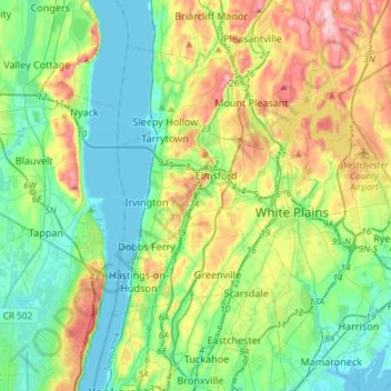
Nombre: Mapa topográfico Saw Mill River, altitud, relieve.
Altitud media: 69 m
Altitud mínima: -2 m
Altitud máxima: 227 m
The Saw Mill River rises from a 1.75-acre (7,100 m2) pond in a wooded area of the town of New Castle roughly 2 miles (3.2 km) north of Chappaqua, a one-half mile (800 m) west of Quaker Road State Route 120 (NY 120) and just south of Stony Hollow Road, at an elevation of 490 feet (150 m) above sea level. It wends and meanders past a cemetery, between hills, through a residential area of houses on large wooded lots in a generally southward direction. Just north of Marcourt Drive, its first crossing, it is impounded to create another small pond. In this area it is frequently channelized and impounded as part of the landscaping on the area's large residential land lots. After crossing under Kipp Street, it bends eastward to cross under Quaker Road.