
Mapa topográfico Ethe
Mapa interactivo
Haga clic en el mapa para ver la altitud.
Acerca de este mapa
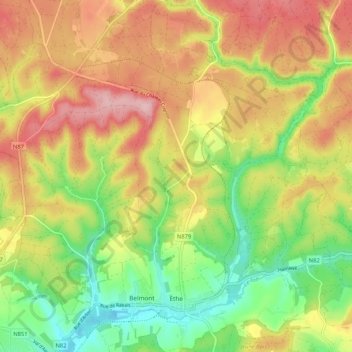
Nombre: Mapa topográfico Ethe, altitud, relieve.
Lugar: Ethe, Virton, Luxembourg, Wallonie, Belgique (49.57154 5.54974 49.63943 5.63094)
Altitud media: 293 m
Altitud mínima: 205 m
Altitud máxima: 384 m
Otros mapas topográficos
Haga clic en un mapa para ver su topografía, su altitud y su relieve.
Saint-Remy
Belgique > Luxembourg > Virton > Virton
Saint-Remy, Virton, Luxembourg, Wallonie, Belgique
Altitud media: 265 m
Gomery
Belgique > Luxembourg > Virton > Virton
Gomery, Virton, Luxembourg, Wallonie, 6760, Belgique
Altitud media: 246 m
Ruette
Belgique > Luxembourg > Virton > Virton
Ruette, Virton, Luxembourg, Wallonie, Belgique
Altitud media: 310 m
Saint-Mard
Belgique > Luxembourg > Virton > Virton
Saint-Mard, Virton, Luxembourg, Wallonie, 6762, Belgique
Altitud media: 272 m