
Mapa topográfico Mount Olympus
Mapa interactivo
Haga clic en el mapa para ver la altitud.
Acerca de este mapa
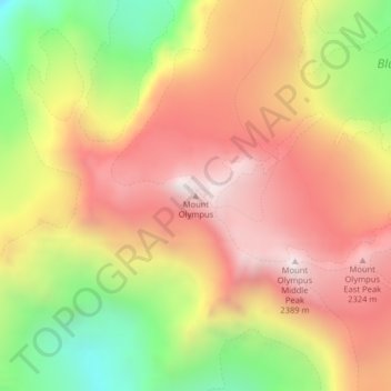
Nombre: Mapa topográfico Mount Olympus, altitud, relieve.
Lugar: Mount Olympus, Jefferson County, Washington, United States (47.80117 -123.71096 47.80127 -123.71086)
Altitud media: 1.934 m
Altitud mínima: 1.337 m
Altitud máxima: 2.396 m
With notable local relief, Mount Olympus ascends over 2,100 m (6,900 ft) from the 293 m (961 ft) elevation confluence of the Hoh River with Glacier Creek in only 8.8 km (5.5 mi). Mount Olympus has 2,386 m (7,828 ft) of prominence, ranking 5th in the state of Washington.