
Gracias por apoyar a este sitio ❤️
Haz una donación
Haz una donación
Mapa topográfico Lomas de Iguanil
Haga clic en el mapa para ver la altitud.
Gracias por apoyar a este sitio ❤️
Haz una donación
Haz una donación
Acerca de este mapa
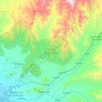
Nombre: Mapa topográfico Lomas de Iguanil, altitud, relieve.
Lugar: Lomas de Iguanil, Huaral, Lima, Perú (-11.45432 -77.26529 -11.36295 -77.09551)
Altitud media: 665 m
Altitud mínima: 166 m
Altitud máxima: 1.808 m
Gracias por apoyar a este sitio ❤️
Haz una donación
Haz una donación
Otros mapas topográficos
Haga clic en un mapa para ver su topografía, su altitud y su relieve.
Gracias por apoyar a este sitio ❤️
Haz una donación
Haz una donación
Gracias por apoyar a este sitio ❤️
Haz una donación
Haz una donación