
Mapa topográfico Arjay
Mapa interactivo
Haga clic en el mapa para ver la altitud.
Acerca de este mapa
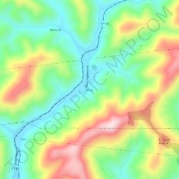
Nombre: Mapa topográfico Arjay, altitud, relieve.
Lugar: Arjay, Bell County, Kentucky, 40902, United States (36.78481 -83.66575 36.82481 -83.62575)
Altitud media: 464 m
Altitud mínima: 305 m
Altitud máxima: 709 m
Otros mapas topográficos
Haga clic en un mapa para ver su topografía, su altitud y su relieve.
Fourmile
United States > Kentucky > Bell County
Fourmile, Bell County, Kentucky, 40939, United States
Altitud media: 406 m
Stoney Fork
United States > Kentucky > Bell County
Stoney Fork, Bell County, Kentucky, United States
Altitud media: 519 m
Beverly
United States > Kentucky > Bell County
Beverly, Bell County, Kentucky, 40913, United States
Altitud media: 526 m
Calvin
United States > Kentucky > Bell County
Calvin, Bell County, Kentucky, 40813, United States
Altitud media: 395 m
Kettle Island
United States > Kentucky > Bell County
Kettle Island, Bell County, Kentucky, 40988, United States
Altitud media: 469 m
Miracle
United States > Kentucky > Bell County
Miracle, Bell County, Kentucky, 40988, United States
Altitud media: 413 m
Middlesborough
United States > Kentucky > Bell County
Middlesborough, Bell County, Kentucky, United States
Altitud media: 406 m
Pineville
United States > Kentucky > Bell County
Pineville, Bell County, Kentucky, United States
Altitud media: 426 m