
Mapa topográfico Champoluc
Mapa interactivo
Haga clic en el mapa para ver la altitud.
Acerca de este mapa
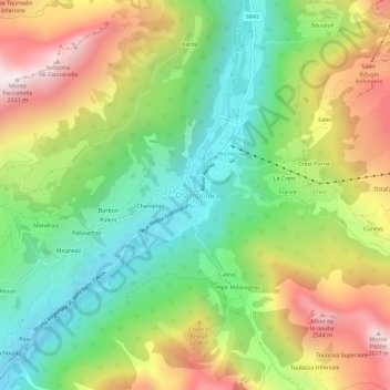
Nombre: Mapa topográfico Champoluc, altitud, relieve.
Lugar: Champoluc, Ayas, Aosta Valley, 11020, Italy (45.81164 7.70600 45.85164 7.74600)
Altitud media: 1.968 m
Altitud mínima: 1.514 m
Altitud máxima: 2.610 m
It is one of the 3 main villages in the commune of Ayas, together with Antagnod (where the town hall is located) and Saint-Jacques. It lies at an altitude of 1568 meters in a broad flat part of the upper Ayas valley. Above Champoluc, to the East, is the Plan du Crest (1975 meters), one of the largest ski areas in the Aosta Valley, reachable by cable car from the centre of the village. In summer, the Crest is a popular place for hiking.
Otros mapas topográficos
Haga clic en un mapa para ver su topografía, su altitud y su relieve.
Ostafa Desot
Italy > Aosta Valley > Ayas
Ostafa Desot, Ayas, Aosta Valley, 11020, Italy
Altitud media: 2.275 m