
Mapa topográfico Langdon Hill
Mapa interactivo
Haga clic en el mapa para ver la altitud.
Acerca de este mapa
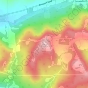
Nombre: Mapa topográfico Langdon Hill, altitud, relieve.
Lugar: Langdon Hill, Chemung County, New York, 14838, United States (42.16641 -76.69306 42.16651 -76.69296)
Altitud media: 449 m
Altitud mínima: 348 m
Altitud máxima: 541 m
Otros mapas topográficos
Haga clic en un mapa para ver su topografía, su altitud y su relieve.
West Elmira
United States > New York > Chemung County
West Elmira, Town of Elmira, Chemung County, New York, 14905, United States
Altitud media: 320 m
Brand Park
United States > New York > Chemung County > City of Elmira
Brand Park, City of Elmira, Chemung County, New York, United States
Altitud media: 270 m
City of Elmira
United States > New York > Chemung County > City of Elmira
City of Elmira, Ashland, Chemung County, New York, United States
Altitud media: 296 m
Village of Millport
United States > New York > Chemung County
Village of Millport, Town of Veteran, Chemung County, New York, United States
Altitud media: 296 m
Lowman
United States > New York > Chemung County
Lowman, Town of Ashland, Chemung County, New York, 14894, United States
Altitud media: 290 m
Village of Horseheads
United States > New York > Chemung County
Village of Horseheads, Town of Horseheads, Veteran, Chemung County, New York, 14845, United States
Altitud media: 298 m