
Mapa topográfico Cleveland
Mapa interactivo
Haga clic en el mapa para ver la altitud.
Acerca de este mapa
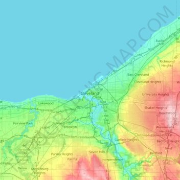
Nombre: Mapa topográfico Cleveland, altitud, relieve.
Lugar: Cleveland, Cuyahoga County, Ohio, 44114, United States (41.34516 -81.85344 41.66516 -81.53344)
Altitud media: 219 m
Altitud mínima: 171 m
Altitud máxima: 385 m
The land rises quickly from the lake shore elevation of 569 feet. Public Square, less than one mile (1.6 km) inland, sits at an elevation of 650 feet (198 m), and Hopkins Airport, 5 miles (8 km) inland from the lake, is at an elevation of 791 feet (241 m).