
Mapa topográfico Genoa
Mapa interactivo
Haga clic en el mapa para ver la altitud.
Acerca de este mapa
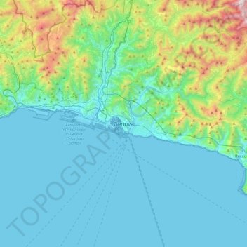
Nombre: Mapa topográfico Genoa, altitud, relieve.
Lugar: Genoa, Liguria, 16100, Italy (44.24726 8.77386 44.56726 9.09386)
Altitud media: 247 m
Altitud mínima: -4 m
Altitud máxima: 1.486 m
The city of Genoa covers an area of 243 square kilometres (94 sq mi) between the Ligurian Sea and the Apennine Mountains. The city stretches along the coast for about 30 kilometres (19 mi) from the neighbourhood of Voltri to Nervi, and for 10 kilometres (6.2 mi) from the coast to the north along the valleys Polcevera and Bisagno. The territory of Genoa is popularly divided into 5 main zones: the centre, the west, the east, the Polcevera and the Bisagno Valley. Although much of downtown is located at a low elevation, the territory surrounding it is mountainous with undeveloped land usually being in steep terrain.
Otros mapas topográficos
Haga clic en un mapa para ver su topografía, su altitud y su relieve.