
Mapa topográfico Sussex
Mapa interactivo
Haga clic en el mapa para ver la altitud.
Acerca de este mapa
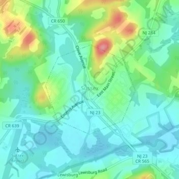
Nombre: Mapa topográfico Sussex, altitud, relieve.
Lugar: Sussex, Sussex County, New Jersey, 10985, United States (41.20284 -74.61655 41.21633 -74.59857)
Altitud media: 142 m
Altitud mínima: 116 m
Altitud máxima: 215 m
Due to its inland location and elevation, Sussex has a climate much cooler than most of the state, classified as humid continental (Köppen Dfa), with cold, moderately snowy winters, and very warm, humid summers. It is part of USDA Plant Hardiness Zone 6. The monthly daily average temperature ranges from 25.8 °F (−3.4 °C) in January to 71.8 °F (22.1 °C) in July. Temperatures reach 90 °F (32 °C) on 13.4 days and fall to 0 °F (−18 °C) on 5.2 nights annually. Snowfall averages 38.7 inches (98 cm) per season, although this usually varies widely from year to year. Extremes in the temperature range from −29 °F (−34 °C) on January 21, 1994 up to 106 °F (41 °C) on July 10, 1936.