
Mapa topográfico Weehawken
Mapa interactivo
Haga clic en el mapa para ver la altitud.
Acerca de este mapa
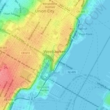
Nombre: Mapa topográfico Weehawken, altitud, relieve.
Lugar: Weehawken, Hudson County, New Jersey, 07086, United States (40.75660 -74.03270 40.78072 -74.00133)
Altitud media: 27 m
Altitud mínima: -2 m
Altitud máxima: 80 m
While the Palisades defines Weehawken's natural topography, the Lincoln Tunnel (which cuts the town in half) looms as an inescapable man-made feature. Geographically, Weehawken has distinct neighborhoods: Downtown, the Heights, Uptown (which includes Kingswood Bluff, known as "The Bluff"), and the Waterfront, which since the 1990s has been developed for transportation, commercial, recreational and residential uses. Though some are long abandoned (e.g., Grauert Causeway), there are still several outdoor public staircases (e.g., Shippen Steps) throughout the town, and more than 15 "dead-end" streets. At its southeastern corner is Weehawken Cove which, along with the rail tracks farther inland, defines Weehawken's border with Hoboken. Its northern boundary is shared with West New York. Traversing Weehawken is Boulevard East, a scenic thoroughfare offering a sweeping vista of the Hudson River and the Manhattan skyline. Local zoning laws prohibit the construction of high-rise buildings that would obstruct sight-lines from higher points in town. In a 1999 decision that blocked the development of a pair of waterfront towers that would have stood 160 feet (49 m), a judge cited the panoramic vistas from Weehawken as "a world-class amenity that encourages people to live, work and locate businesses in the area". In 2021, the development company Roseland donated 14.5 acres of the Palisades cliff face to the town in order to preserve its beauty and its history.