
Mapa topográfico Meteora
Mapa interactivo
Haga clic en el mapa para ver la altitud.
Acerca de este mapa
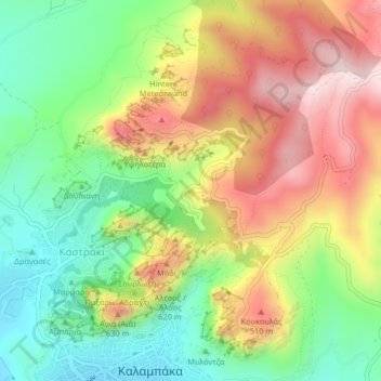
Nombre: Mapa topográfico Meteora, altitud, relieve.
Altitud media: 429 m
Altitud mínima: 227 m
Altitud máxima: 678 m
The Monastery of Rousanou is believed to have been constructed, like many of the other monasteries, in the 14th century. The cathedral is believed to have been built in the 16th century and later decorated in 1540. The name Rousanou is believed to come from the first group of monks who settled on the rock from Russia. The monastery sits on the elevation 484 meters. Lying in the middle of the site, visitors can see the other monasteries, as well as the ruins of the Monastery of St. John the Baptist and the Pantokrator.