
Mapa topográfico Municipality of Nemea
Mapa interactivo
Haga clic en el mapa para ver la altitud.
Acerca de este mapa
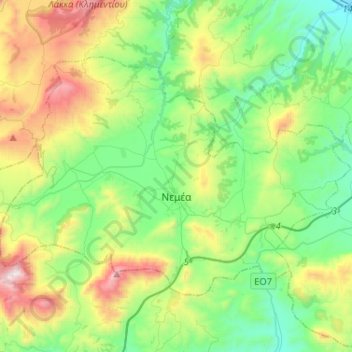
Nombre: Mapa topográfico Municipality of Nemea, altitud, relieve.
Altitud media: 461 m
Altitud mínima: 50 m
Altitud máxima: 1.410 m
Nemea (altitude ca. 300m) is situated in a relatively plain basin surrounded by mountains, that reach ca. 750m.. The ancient town, Αρχαία Νεμέα, (at ca. 360m) is in a somewhat smaller basin to the east. Both basins empty through their own valley into the Gulf of Corinth. The surface of the two basins varies by only a few meters. The soil contains weathered elements of Limestone. The composition of the soil, the basin's geology, the altitude and the climate are ideal for viticulture.
Otros mapas topográficos
Haga clic en un mapa para ver su topografía, su altitud y su relieve.
Ancient Korinthos
Greece > Peloponnese, Western Greece and the Ionian > Corinthia Regional Unit > Municipal Unit of Corinth
Ancient Korinthos, Municipal Unit of Corinth, Municipality of Corinth, Corinthia Regional Unit, Peloponnese Region, Peloponnese, Western Greece and the Ionian, 200 07, Greece
Altitud media: 101 m
Municipal Unit of Velos
Greece > Peloponnese, Western Greece and the Ionian > Corinthia Regional Unit
Municipal Unit of Velos, Municipality of Velo and Vocha, Corinthia Regional Unit, Peloponnese Region, Peloponnese, Western Greece and the Ionian, 200 02, Greece
Altitud media: 276 m
Velo
Greece > Peloponnese, Western Greece and the Ionian > Corinthia Regional Unit > Municipal Unit of Velos
Velo, Municipal Unit of Velos, Municipality of Velo and Vocha, Corinthia Regional Unit, Peloponnese Region, Peloponnese, Western Greece and the Ionian, 200 02, Greece
Altitud media: 50 m
Municipal Unit of Loutraki - Perachora
Greece > Peloponnese, Western Greece and the Ionian > Corinthia Regional Unit
Municipal Unit of Loutraki - Perachora, Loutraki-Perachora-Agioi Theodoroi Municipality, Corinthia Regional Unit, Peloponnese Region, Peloponnese, Western Greece and the Ionian, Greece
Altitud media: 170 m
Municipal Unit of Sikyona
Greece > Peloponnese, Western Greece and the Ionian > Corinthia Regional Unit
Municipal Unit of Sikyona, Municipality of Sikyona, Corinthia Regional Unit, Peloponnese Region, Peloponnese, Western Greece and the Ionian, Greece
Altitud media: 478 m
Corinth
Greece > Peloponnese, Western Greece and the Ionian > Corinthia Regional Unit
Corinth, Municipal Unit of Corinth, Municipality of Corinth, Corinthia Regional Unit, Peloponnese Region, Peloponnese, Western Greece and the Ionian, 201 00, Greece
Altitud media: 185 m
Γεράνεια (Λουτρακίου-Περαχώρας)
Greece > Peloponnese, Western Greece and the Ionian > Corinthia Regional Unit > Municipal Unit of Loutraki - Perachora
Γεράνεια (Λουτρακίου-Περαχώρας), Municipal Unit of Loutraki - Perachora, Loutraki-Perachora-Agioi Theodoroi Municipality, Corinthia Regional Unit, Peloponnese Region, Peloponnese, Western Greece and the Ionian, 203 00, Greece
Altitud media: 390 m