
Haz una donación
Mapa topográfico West Bend
Haga clic en el mapa para ver la altitud.
Haz una donación
West Bend
West Bend is in the Kettle Moraine region, and its topography is varied. The glacial activity has formed many kettles and hills throughout the region.
Haz una donación
Acerca de este mapa
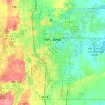
Nombre: Mapa topográfico West Bend, altitud, relieve.
Lugar: West Bend, Washington County, Wisconsin, United States (43.37029 -88.24651 43.45555 -88.11013)
Altitud media: 298 m
Altitud mínima: 260 m
Altitud máxima: 366 m
Haz una donación
Otros mapas topográficos
Haga clic en un mapa para ver su topografía, su altitud y su relieve.
Milwaukee River Floodplain Forest State Natural Area
United States > Wisconsin > Washington County
Altitud media: 291 m
Allenton
United States > Wisconsin > Washington County
Allenton is located at latitude 43.421 and longitude -88.341. The elevation is 958 feet. Allenton has an area of 1.446 square miles (3.75 km2), all of it land. The Rock River cuts through the town.
Altitud media: 313 m