
Mapa topográfico Wilmington
Mapa interactivo
Haga clic en el mapa para ver la altitud.
Wilmington
On the western side of Market Street, the Piedmont topography is rocky and hilly, rising to a point that marks the watershed between the Brandywine River and the Christina River. This watershed line runs along Delaware Avenue westward from 10th Street and Market Street.
Acerca de este mapa
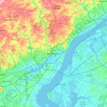
Nombre: Mapa topográfico Wilmington, altitud, relieve.
Altitud media: 43 m
Altitud mínima: -5 m
Altitud máxima: 170 m