
Mapa topográfico Monroe County
Mapa interactivo
Haga clic en el mapa para ver la altitud.
Acerca de este mapa
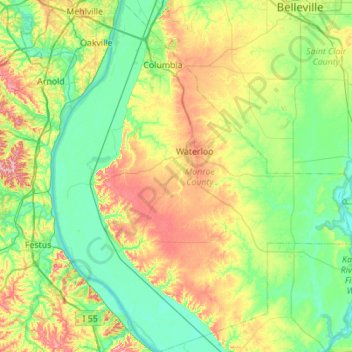
Nombre: Mapa topográfico Monroe County, altitud, relieve.
Lugar: Monroe County, Illinois, United States of America (38.08791 -90.37305 38.52073 -89.89674)
Altitud media: 157 m
Altitud mínima: 108 m
Altitud máxima: 269 m
The western part of the county on the Mississippi River is part of the American Bottom floodplain, while the eastern portion of the county is relatively flat and was originally prairie. The transition zone between has high bluffs of limestone and dolomite and has distinctive Karst topography with numerous sinkholes, caves, and springs.
Otros mapas topográficos
Haga clic en un mapa para ver su topografía, su altitud y su relieve.
Marshall County
United States of America > Illinois
Marshall County, Illinois, United States of America
Altitud media: 201 m
Richland County
United States of America > Illinois
Richland County, Illinois, United States of America
Altitud media: 145 m
Springfield
United States of America > Illinois > Springfield
Springfield, Sangamon County, Illinois, United States of America
Altitud media: 178 m
Vergennes
United States of America > Illinois > Vergennes > Vergennes
Vergennes, Jackson County, Illinois, United States of America
Altitud media: 121 m
Gallatin County
United States of America > Illinois
Gallatin County, Illinois, United States of America
Altitud media: 122 m
DeKalb County
United States of America > Illinois
DeKalb County, Illinois, United States of America
Altitud media: 253 m
Henry County
United States of America > Illinois
Henry County, Illinois, United States of America
Altitud media: 214 m