
Mapa topográfico Abucay
Mapa interactivo
Haga clic en el mapa para ver la altitud.
Abucay
Topography of Abucay varies from the mountainous terrain of Mount Natib caldera in the west to the coastal areas of the province along the shore of Manila Bay. Six rivers with a combined length of 37 kilometres (23 mi) originate from the mountain flowing in the west-to-east direction.
Acerca de este mapa
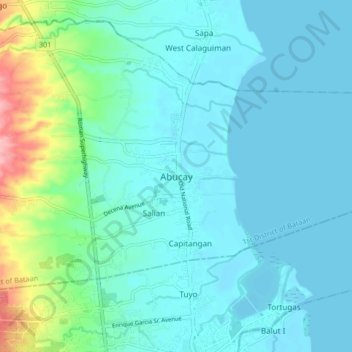
Nombre: Mapa topográfico Abucay, altitud, relieve.
Lugar: Abucay, Bataan, Central Luzon, 2114, Philippines (14.68131 120.49487 14.76131 120.57487)
Altitud media: 22 m
Altitud mínima: 0 m
Altitud máxima: 129 m