
Mapa topográfico Brukom
Mapa interactivo
Haga clic en el mapa para ver la altitud.
Acerca de este mapa
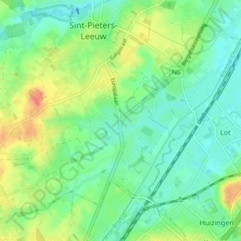
Nombre: Mapa topográfico Brukom, altitud, relieve.
Altitud media: 39 m
Altitud mínima: 21 m
Altitud máxima: 72 m
Otros mapas topográficos
Haga clic en un mapa para ver su topografía, su altitud y su relieve.
Oudenaken
België > Vlaams-Brabant > Halle-Vilvoorde > Sint-Pieters-Leeuw
Oudenaken, Sint-Pieters-Leeuw, Halle-Vilvoorde, Vlaams-Brabant, België
Altitud media: 41 m
Sint-Pieters-Leeuw
België > Vlaams-Brabant > Halle-Vilvoorde > Sint-Pieters-Leeuw
Sint-Pieters-Leeuw, Halle-Vilvoorde, Vlaams-Brabant, 1600, België
Altitud media: 42 m
Sobroek
België > Vlaams-Brabant > Halle-Vilvoorde > Sint-Pieters-Leeuw > Vlezenbeek
Sobroek, Vlezenbeek, Sint-Pieters-Leeuw, Halle-Vilvoorde, Vlaams-Brabant, Vlaanderen, 1602, België
Altitud media: 42 m
Vlezenbeek
België > Vlaams-Brabant > Halle-Vilvoorde > Sint-Pieters-Leeuw
Vlezenbeek, Sint-Pieters-Leeuw, Halle-Vilvoorde, Vlaams-Brabant, 1602, België
Altitud media: 47 m
Ruisbroek
België > Vlaams-Brabant > Halle-Vilvoorde > Sint-Pieters-Leeuw
Ruisbroek, Sint-Pieters-Leeuw, Halle-Vilvoorde, Vlaams-Brabant, 1601, België
Altitud media: 29 m