
Mapa topográfico Fremont
Mapa interactivo
Haga clic en el mapa para ver la altitud.
Acerca de este mapa
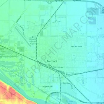
Nombre: Mapa topográfico Fremont, altitud, relieve.
Lugar: Fremont, Dodge County, Nebraska, 68025, United States (41.41630 -96.54123 41.46409 -96.44426)
Altitud media: 365 m
Altitud mínima: 355 m
Altitud máxima: 414 m
According to the United States Census Bureau, the city has a total area of 8.85 square miles (22.92 km2), of which 8.80 square miles (22.79 km2) is land and 0.05 square miles (0.13 km2) is water. Fremont lies in the river plain between the Platte and Elkhorn rivers, at an elevation of approximately 366 meters (1,203 ft) above sea level.
Otros mapas topográficos
Haga clic en un mapa para ver su topografía, su altitud y su relieve.
Fremont
United States > Nebraska > Dodge County > Fremont
Fremont, Dodge County, Nebraska, 68025, United States
Altitud media: 378 m