
Mapa topográfico Wood Valley
Mapa interactivo
Haga clic en el mapa para ver la altitud.
Acerca de este mapa
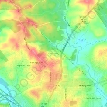
Nombre: Mapa topográfico Wood Valley, altitud, relieve.
Altitud media: 120 m
Altitud mínima: 84 m
Altitud máxima: 158 m
Otros mapas topográficos
Haga clic en un mapa para ver su topografía, su altitud y su relieve.
Heritage Acres
United States > Georgia > Bibb County > Macon
Heritage Acres, Macon, Bibb County, Georgia, 31211, United States
Altitud media: 119 m
Sofkee
United States > Georgia > Bibb County > Macon
Sofkee, Macon, Bibb County, Georgia, 31297, United States
Altitud media: 110 m
Avondale
United States > Georgia > Bibb County > Macon
Avondale, Macon, Bibb County, Georgia, 31297, United States
Altitud media: 98 m
Lake Arrowhead
United States > Georgia > Bibb County > Macon
Lake Arrowhead, Macon, Bibb County, Georgia, 31217, United States
Altitud media: 137 m
Christophers Cove
United States > Georgia > Bibb County > Macon
Christophers Cove, Macon, Bibb County, Georgia, 31220, United States
Altitud media: 130 m
Lizella
United States > Georgia > Bibb County > Macon > Lizella
Lizella, Macon, Bibb County, Georgia, 31052, United States
Altitud media: 146 m
Ocmulgee Mounds National Historical Park
United States > Georgia > Bibb County > Macon
Ocmulgee Mounds National Historical Park, Short Circle, Macon, Bibb County, Georgia, 31201-1662, United States
Altitud media: 96 m
Idlewood
United States > Georgia > Bibb County > Macon
Idlewood, Macon, Bibb County, Georgia, 31210, United States
Altitud media: 132 m