
Gracias por apoyar a este sitio ❤️
Haz una donación
Haz una donación
Mapa topográfico Jirishanca
Haga clic en el mapa para ver la altitud.
Gracias por apoyar a este sitio ❤️
Haz una donación
Haz una donación
Jirishanca
The altitude of 6125 isn't likely as other data from available digital elevation models show lower elevations: SRTM yields 6028 metres and TanDEM-X 5734 metres. The height of the nearest key col is 5610 meters, leading to a topographic prominence of 484 meters. Jirishanca is considered a Mountain according to the Dominance System and its dominance is 7.94%. Its parent peak is Yerupaja and the Topographic isolation is 3.5 kilometers.
Gracias por apoyar a este sitio ❤️
Haz una donación
Haz una donación
Acerca de este mapa
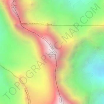
Nombre: Mapa topográfico Jirishanca, altitud, relieve.
Lugar: Jirishanca, Pacllón, Province of Bolognesi, Ancash, Peru (-10.23703 -76.90579 -10.23693 -76.90569)
Altitud media: 5.198 m
Altitud mínima: 4.510 m
Altitud máxima: 5.907 m
Gracias por apoyar a este sitio ❤️
Haz una donación
Haz una donación