
Mapa topográfico Gençlik Parkı
Mapa interactivo
Haga clic en el mapa para ver la altitud.
Acerca de este mapa
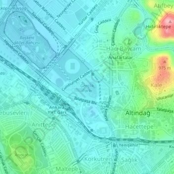
Nombre: Mapa topográfico Gençlik Parkı, altitud, relieve.
Altitud media: 870 m
Altitud mínima: 842 m
Altitud máxima: 1.000 m
The 27.5 ha (68 acres) park is almost at the center of Ankara. Its altitude is about 850 m (2,790 ft), which makes it one of the lowest points in Ankara. It is surrounded by Ulus Square to the north, the Ankara Opera House (formerly Ankara Exhibition Building) to the east, Selim Sırrı Tarcan Sport Hall and Ankara Central Station to the south and, 19 Mayıs Stadium to the west.
Otros mapas topográficos
Haga clic en un mapa para ver su topografía, su altitud y su relieve.