
Mapa topográfico Dolpa
Mapa interactivo
Haga clic en el mapa para ver la altitud.
Acerca de este mapa
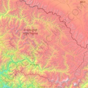
Nombre: Mapa topográfico Dolpa, altitud, relieve.
Lugar: Dolpa, Karnali Province, Nepal (28.72190 82.39256 29.70741 83.67995)
Altitud media: 4.555 m
Altitud mínima: 972 m
Altitud máxima: 8.065 m
Dolpa is the largest district of Nepal covering 5.36% of the total landmass of the country. It is located at 28°43’N to 29°43’N latitude and 82°23’E to 83°41’E longitude. Elevation ranges from 1,525 to 7,625 m (5,003 to 25,016 ft). The district borders Tibet on the north and northeast, Jumla and Mugu districts on the west, Myagdi, Jajarkot, Western and Eastern Rukum on the south, and Mustang on the east.
Otros mapas topográficos
Haga clic en un mapa para ver su topografía, su altitud y su relieve.
Pokhra
Nepal > Karnali Province > Dailekh
Pokhra, Gurans-02, Gurans, Dailekh, Karnali Province, Nepal
Altitud media: 1.106 m
Chhinchu
Nepal > Karnali Province > Surkhet
Chhinchu, Bheriganga, Surkhet, Karnali Province, Nepal
Altitud media: 625 m