
Mapa topográfico Elkins
Mapa interactivo
Haga clic en el mapa para ver la altitud.
Acerca de este mapa
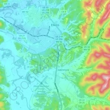
Nombre: Mapa topográfico Elkins, altitud, relieve.
Lugar: Elkins, Randolph County, West Virginia, 26241, United States (38.87325 -79.87408 38.94134 -79.83184)
Altitud media: 637 m
Altitud mínima: 576 m
Altitud máxima: 861 m
Elkins is located at the confluence of the Tygart Valley River and Leading Creek. The average elevation is 2,000 feet (610 m) above sea level. According to the United States Census Bureau, the city has a total area of 3.43 square miles (8.88 km2), all land. Elkins is headquarters for the Monongahela National Forest, a 910,155-acre (368,327 ha) federal reserve encompassing the "High Alleghenies" area to the east of the city.