
Mapa topográfico Peristeri
Mapa interactivo
Haga clic en el mapa para ver la altitud.
Acerca de este mapa
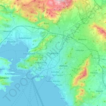
Nombre: Mapa topográfico Peristeri, altitud, relieve.
Altitud media: 223 m
Altitud mínima: -3 m
Altitud máxima: 1.365 m
Otros mapas topográficos
Haga clic en un mapa para ver su topografía, su altitud y su relieve.
Municipal Unit of Kamatero
Greece > Attica > Regional Unit of West Athens
Municipal Unit of Kamatero, Municipality of Agioi Anargyroi-Kamatero, Regional Unit of West Athens, Attica, 134 51, Greece
Altitud media: 153 m
Municipality of Aigaleo
Greece > Attica > Regional Unit of West Athens
Municipality of Aigaleo, Regional Unit of West Athens, Attica, Greece
Altitud media: 46 m
Municipality of Petroupoli
Greece > Attica > Regional Unit of West Athens
Municipality of Petroupoli, Regional Unit of West Athens, Attica, 132 31, Greece
Altitud media: 222 m
Municipality of Peristeri
Greece > Attica > Regional Unit of West Athens
Municipality of Peristeri, Regional Unit of West Athens, Attica, Greece
Altitud media: 80 m