
Haz una donación
Mapa topográfico Denmark
Haga clic en el mapa para ver la altitud.
Haz una donación
Acerca de este mapa
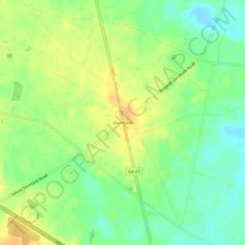
Nombre: Mapa topográfico Denmark, altitud, relieve.
Lugar: Denmark, Bulloch County, Georgia, United States (32.26463 -81.74400 32.30463 -81.70400)
Altitud media: 45 m
Altitud mínima: 29 m
Altitud máxima: 60 m
Haz una donación
Otros mapas topográficos
Haga clic en un mapa para ver su topografía, su altitud y su relieve.
Statesboro
United States > Georgia > Bulloch County
According to the United States Census Bureau, the city has a total area of 13.9 square miles (35.9 km2), of which 13.5 square miles (35.0 km2) is land and 0.35 square miles (0.9 km2), or 2.60%, is water. The city is in the coastal plain region, or Low Country, of Georgia, so it is mainly flat with a few small…
Altitud media: 64 m
Haz una donación
Statesboro
United States > Georgia > Bulloch County
According to the United States Census Bureau, the city has a total area of 13.9 square miles (35.9 km2), of which 13.5 square miles (35.0 km2) is land and 0.35 square miles (0.9 km2), or 2.60%, is water. The city is in the coastal plain region, or Low Country, of Georgia, so it is mainly flat with a few small…
Altitud media: 64 m