
Mapa topográfico Espanola
Mapa interactivo
Haga clic en el mapa para ver la altitud.
Espanola
Española lies at an elevation of around 5,595 feet (1,705 m) with much variance. It is in a valley nestled between the Jemez and Sangre de Cristo mountain ranges, and the meeting point of three rivers, the Rio Grande, the Rio Chama, and the Rio Santa Cruz.
Acerca de este mapa
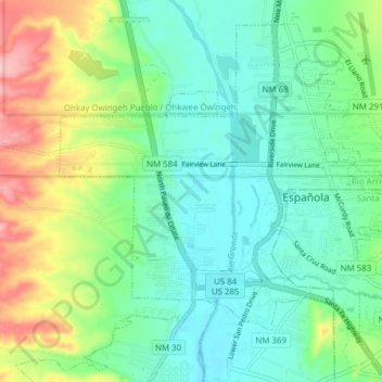
Nombre: Mapa topográfico Espanola, altitud, relieve.
Altitud media: 1.739 m
Altitud mínima: 1.697 m
Altitud máxima: 1.839 m