
Mapa topográfico Lānaʻi
Mapa interactivo
Haga clic en el mapa para ver la altitud.
Acerca de este mapa
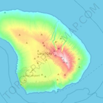
Nombre: Mapa topográfico Lānaʻi, altitud, relieve.
Lugar: Lānaʻi, Maui County, Hawaii, 96763, United States (20.73171 -157.06163 20.92934 -156.80555)
Altitud media: 162 m
Altitud mínima: 0 m
Altitud máxima: 1.020 m
The highest point in Lanai is Mount Lānaʻihale. It is an inactive volcano near the center of the island and to the east of Lanai City. The elevation of Mount Lānaʻihale is 3,366 ft (1,026 m).
Otros mapas topográficos
Haga clic en un mapa para ver su topografía, su altitud y su relieve.
ʻĪao Valley State Monument
United States > Hawaii > Maui County
ʻĪao Valley State Monument, Maui County, Hawaii, United States
Altitud media: 629 m