
Mapa topográfico Schwanham
Mapa interactivo
Haga clic en el mapa para ver la altitud.
Acerca de este mapa
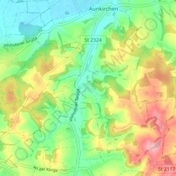
Nombre: Mapa topográfico Schwanham, altitud, relieve.
Altitud media: 369 m
Altitud mínima: 313 m
Altitud máxima: 450 m
Otros mapas topográficos
Haga clic en un mapa para ver su topografía, su altitud y su relieve.
Sollasöd
Deutschland > Bayern > Landkreis Passau > Vilshofen an der Donau > Lindach
Sollasöd, Lindach, Vilshofen an der Donau, Landkreis Passau, Bayern, 94474, Deutschland
Altitud media: 358 m
Reut
Deutschland > Bayern > Landkreis Passau > Vilshofen an der Donau > Aunkirchen
Reut, Aunkirchen, Vilshofen an der Donau, Landkreis Passau, Bayern, 94501, Deutschland
Altitud media: 352 m
Schönerting
Deutschland > Bayern > Landkreis Passau > Vilshofen an der Donau > Schönerting
Schönerting, Vilshofen an der Donau, Landkreis Passau, Bayern, 94501, Deutschland
Altitud media: 342 m
Pleinting
Deutschland > Bayern > Landkreis Passau > Vilshofen an der Donau
Pleinting, Vilshofen an der Donau, Landkreis Passau, Bayern, 94544, Deutschland
Altitud media: 334 m