
Haz una donación
Mapa topográfico Fort Mountain
Haga clic en el mapa para ver la altitud.
Haz una donación
Acerca de este mapa
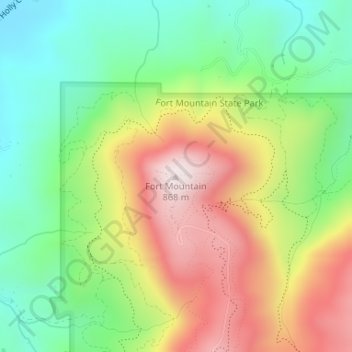
Nombre: Mapa topográfico Fort Mountain, altitud, relieve.
Lugar: Fort Mountain, Murray County, Georgia, United States (34.78281 -84.70915 34.78291 -84.70905)
Altitud media: 510 m
Altitud mínima: 251 m
Altitud máxima: 863 m
Haz una donación
Otros mapas topográficos
Haga clic en un mapa para ver su topografía, su altitud y su relieve.
Chatsworth
United States > Georgia > Murray County
Chatsworth is located in central Murray County at 34°46′20″N 84°46′44″W / 34.77222°N 84.77889°W / 34.77222; -84.77889 (34.772336, -84.778977), in northwestern Georgia. It sits at an elevation of 750 feet (230 m) on the west side of the valley of Holly Creek, with 2,840-foot (870 m) Fort…
Altitud media: 241 m