
Gracias por apoyar a este sitio ❤️
Haz una donación
Haz una donación
Mapa topográfico Cooperville
Haga clic en el mapa para ver la altitud.
Gracias por apoyar a este sitio ❤️
Haz una donación
Haz una donación
Acerca de este mapa
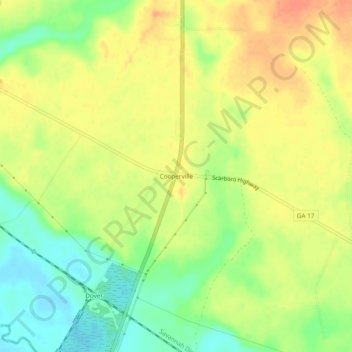
Nombre: Mapa topográfico Cooperville, altitud, relieve.
Lugar: Cooperville, Screven County, Georgia, United States (32.57073 -81.72400 32.61073 -81.68400)
Altitud media: 47 m
Altitud mínima: 22 m
Altitud máxima: 67 m
Gracias por apoyar a este sitio ❤️
Haz una donación
Haz una donación
Otros mapas topográficos
Haga clic en un mapa para ver su topografía, su altitud y su relieve.
Sylvania
United States > Georgia > Screven County
According to the United States Census Bureau, the city has a total area of 3.8 square miles (9.8 km2), all land. Sylvania's elevation is 230 feet and is slightly higher than most of the land throughout Screven County.
Altitud media: 60 m