
Mapa topográfico Episkopi
Mapa interactivo
Haga clic en el mapa para ver la altitud.
Acerca de este mapa
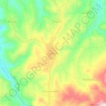
Nombre: Mapa topográfico Episkopi, altitud, relieve.
Altitud media: 289 m
Altitud mínima: 121 m
Altitud máxima: 491 m
Aitania village is located on a hill west of Episkopi village, in the inland of Hersonissos Municipality, and on the east of Karteros Potamos Valley with a northern view to the sea, at an altitude of 255 m. The population is approximately 319 inhabitants. Its churches and the landscape of the valley of Karteros Potamos make it a destination for tourists. There are traditional cafes in the cobblestoned square of the village where orange trees, mulberry, oleanders and pomegranates grow. Churches include Agios Ioannis, Genesis of Theotokou and Agia Paraskeuh, all three of them dating to the 13th century.