
Gracias por apoyar a este sitio ❤️
Haz una donación
Haz una donación
Mapa topográfico Gallatin River
Haga clic en el mapa para ver la altitud.
Gracias por apoyar a este sitio ❤️
Haz una donación
Haz una donación
Acerca de este mapa
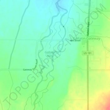
Nombre: Mapa topográfico Gallatin River, altitud, relieve.
Altitud media: 1.509 m
Altitud mínima: 1.489 m
Altitud máxima: 1.550 m
Gracias por apoyar a este sitio ❤️
Haz una donación
Haz una donación
Otros mapas topográficos
Haga clic en un mapa para ver su topografía, su altitud y su relieve.
Bozeman
United States > Montana > Gallatin County
Bozeman is located at an elevation of 4,820 feet (1,470 m). The Bridger Mountains are to the north-northeast, the Tobacco Root Mountains to the west-southwest, the Big Belt Mountains and Horseshoe Hills to the northwest, the Hyalite Peaks of the northern Gallatin Range to the south and the Spanish Peaks of the…
Altitud media: 1.679 m
Gracias por apoyar a este sitio ❤️
Haz una donación
Haz una donación
Big Sky Canyon Village
United States > Montana > Gallatin County > Big Sky Canyon Village
Altitud media: 1.994 m