
Mapa topográfico Providence County
Mapa interactivo
Haga clic en el mapa para ver la altitud.
Acerca de este mapa
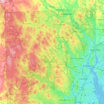
Nombre: Mapa topográfico Providence County, altitud, relieve.
Lugar: Providence County, Rhode Island, United States of America (41.72452 -71.79925 42.01894 -71.31774)
Altitud media: 108 m
Altitud mínima: -7 m
Altitud máxima: 272 m
Otros mapas topográficos
Haga clic en un mapa para ver su topografía, su altitud y su relieve.
Cranston
United States of America > Rhode Island > Cranston
Cranston, Providence County, Rhode Island, United States of America
Altitud media: 27 m
Warwick
United States of America > Rhode Island > Warwick
Warwick, Kent County, Rhode Island, United States of America
Altitud media: 17 m