
Mapa topográfico Evans County
Mapa interactivo
Haga clic en el mapa para ver la altitud.
Acerca de este mapa
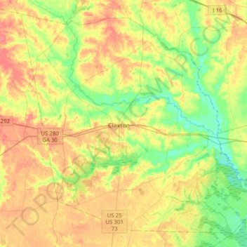
Nombre: Mapa topográfico Evans County, altitud, relieve.
Lugar: Evans County, Georgia, United States of America (32.04790 -82.02575 32.27889 -81.71866)
Altitud media: 47 m
Altitud mínima: 19 m
Altitud máxima: 78 m
Air travel in Evans County is provided by the Claxton-Evans County Airport. The site for the airport was approved by the FAA in 1964 and it was activated in 1971; the airport is three miles (5 km) northeast of Claxton, Georgia. It is operated by the city of Claxton. It has a 5,000-foot (1,500 m) runway, hangars, pilot control lighting, and a Precision Approach Path Indicator. The Claxton-Evans County Airport has an elevation of 112 ft (34.1 m).
Otros mapas topográficos
Haga clic en un mapa para ver su topografía, su altitud y su relieve.
Murray County
United States of America > Georgia
Murray County, Georgia, United States of America
Altitud media: 381 m
Coffee County
United States of America > Georgia
Coffee County, Georgia, United States of America
Altitud media: 72 m
Bibb County
United States of America > Georgia
Bibb County, Georgia, United States of America
Altitud media: 128 m