
Mapa topográfico Ely
Mapa interactivo
Haga clic en el mapa para ver la altitud.
Acerca de este mapa
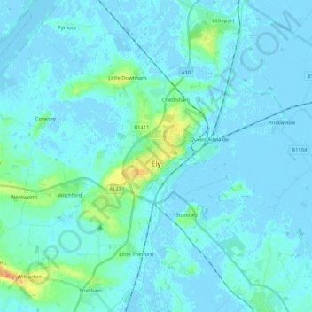
Nombre: Mapa topográfico Ely, altitud, relieve.
Altitud media: 4 m
Altitud mínima: -5 m
Altitud máxima: 36 m
Ely is built on a 23-square-mile (60 km2) Kimmeridge Clay island which, at 85 feet (26 m), is the highest land in the Fens. It was due to this topography that Ely was not waterlogged like the surrounding Fenland, and was an island separated from the mainland. Major rivers including the Witham, Welland, Nene and Great Ouse feed into the Fens and, until draining commenced in the eighteenth century, formed freshwater marshes and meres within which peat was laid down. Once the Fens were drained, this peat created a rich and fertile soil ideal for farming.
Otros mapas topográficos
Haga clic en un mapa para ver su topografía, su altitud y su relieve.
South Cambridgeshire
United Kingdom > England > Cambridgeshire
South Cambridgeshire, Cambridgeshire, Cambridgeshire and Peterborough, England, United Kingdom
Altitud media: 42 m
Great Paxton
United Kingdom > England > Cambridgeshire > Huntingdonshire
Great Paxton, Huntingdonshire, Cambridgeshire, Cambridgeshire and Peterborough, England, United Kingdom
Altitud media: 34 m
Kimbolton
United Kingdom > England > Cambridgeshire > Huntingdonshire > Kimbolton
Kimbolton, Huntingdonshire, Cambridgeshire, Cambridgeshire and Peterborough, England, United Kingdom
Altitud media: 54 m
Cambridge
United Kingdom > England > Cambridgeshire
Cambridge, Cambridgeshire, Cambridgeshire and Peterborough, England, United Kingdom
Altitud media: 18 m
Godmanchester
United Kingdom > England > Cambridgeshire > Huntingdonshire
Huntingdon, Godmanchester, Huntingdonshire, Cambridgeshire, Cambridgeshire and Peterborough, England, United Kingdom
Altitud media: 25 m
Holme
United Kingdom > England > Cambridgeshire > Huntingdonshire
Holme, Huntingdonshire, Cambridgeshire, Cambridgeshire and Peterborough, England, United Kingdom
Altitud media: 1 m