
Mapa topográfico Prior Lake
Mapa interactivo
Haga clic en el mapa para ver la altitud.
Acerca de este mapa
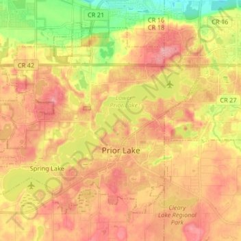
Nombre: Mapa topográfico Prior Lake, altitud, relieve.
Lugar: Prior Lake, Scott County, Minnesota, 55372, United States (44.68860 -93.51201 44.76124 -93.37963)
Altitud media: 282 m
Altitud mínima: 220 m
Altitud máxima: 326 m
The eastern portion of Spring Lake along Scott County Road 12 is also located within the City of Prior Lake. Spring Lake, with 290 acres, but being a few minutes further out from the metro area offers similar recreational opportunities as Upper Prior Lake with a more rural character and less traffic. Spring Lake, being several feet higher in elevation, flows north, into Upper Prior Lake via a non-navigable spillway and culvert under County Road 12.
Otros mapas topográficos
Haga clic en un mapa para ver su topografía, su altitud y su relieve.
Eagle Creek
United States > Minnesota > Scott County
Eagle Creek, Scott County, Minnesota, United States
Altitud media: 284 m
Shakopee
United States > Minnesota > Scott County > Shakopee > Shakopee
Shakopee, Scott County, Minnesota, 55379, United States
Altitud media: 248 m
Savage
United States > Minnesota > Scott County > Savage > Savage
Savage, Scott County, Minnesota, 55378, United States
Altitud media: 251 m
Shakopee
United States > Minnesota > Scott County
Shakopee, Scott County, Minnesota, 55379, United States
Altitud media: 257 m
Savage
United States > Minnesota > Scott County
Savage, Scott County, Minnesota, 55378, United States
Altitud media: 262 m