
Mapa topográfico River Foyle
Mapa interactivo
Haga clic en el mapa para ver la altitud.
Acerca de este mapa
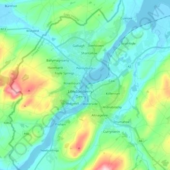
Nombre: Mapa topográfico River Foyle, altitud, relieve.
Altitud media: 61 m
Altitud mínima: -4 m
Altitud máxima: 273 m
Otros mapas topográficos
Haga clic en un mapa para ver su topografía, su altitud y su relieve.
Magilligan
United Kingdom > Northern Ireland > Londonderry/Derry
Magilligan, Aughil, Londonderry/Derry, County Londonderry, Northern Ireland, United Kingdom
Altitud media: 81 m
Lough Foyle
United Kingdom > Northern Ireland > Londonderry/Derry
Lough Foyle, Londonderry/Derry, County Londonderry, Northern Ireland, United Kingdom
Altitud media: 61 m
Termonbacca
United Kingdom > Northern Ireland > Londonderry/Derry
Termonbacca, Londonderry/Derry, County Londonderry, Northern Ireland, United Kingdom
Altitud media: 74 m
Mullaghmore
United Kingdom > Northern Ireland > Londonderry/Derry
Mullaghmore, Londonderry/Derry, County Londonderry, Northern Ireland, United Kingdom
Altitud media: 389 m
Loughermore
United Kingdom > Northern Ireland > Londonderry/Derry
Loughermore, Londonderry/Derry, County Londonderry, Northern Ireland, United Kingdom
Altitud media: 294 m
Edenballymore
United Kingdom > Northern Ireland > Londonderry/Derry
Edenballymore, Londonderry/Derry, County Londonderry, Northern Ireland, United Kingdom
Altitud media: 41 m
Benbradagh
United Kingdom > Northern Ireland > Londonderry/Derry
Benbradagh, Londonderry/Derry, County Londonderry, Northern Ireland, BT47 4QN, United Kingdom
Altitud media: 252 m